

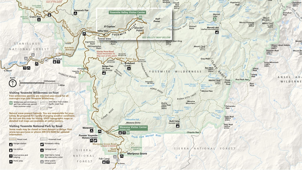
The Yosemite National Park Map PDF is an excellent resource for visitors to the park. The map includes all the trails, campgrounds, and points of interest and has a detailed Yosemite Valley map. It is also an excellent way to plan your trip before you leave.
The map can be downloaded for free as a PDF or printed out.
Yosemite National Park Map (Official)
In my case, before visiting Yosemite, I downloaded every single map I could find and saved them to Evernote, making sure I synchronized them with every mobile device I own. While visiting the park, I always had access to Yosemite maps, even without a mobile connection.

Consider Detailed Topographic Map for Yosemite
If you plan extensive hiking and backpacking in Yosemite, I highly recommend getting a professional-grade topographic map from National Geographic.
Every Trails Illustrated map is printed on “Backcountry Tough” waterproof, tear-resistant paper. An entire UTM grid is published on the map to aid GPS navigation.
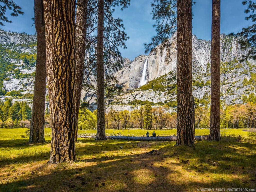
A visit to Yosemite National Park is a must for anyone who loves the outdoors. With its soaring mountains, rushing waterfalls, and acres of wildflowers, the park is a haven for hikers, climbers, and nature lovers of all kinds. The park also offers a variety of activities for visitors who want to explore its history and culture.
Four key highlights of Yosemite National Park include the High Sierra, Granite Cliffs, Sequoia Groves, and Yosemite Valley. See the official Yosemite National Park maps to locate each focal point.
Yosemite Valley Map
Yosemite Valley is the most popular and busiest area of Yosemite National Park. The valley offers stunning views of Half Dome, El Capitan, Yosemite Falls, and many other iconic landmarks. Camping, hiking, biking, climbing, and fishing are all available in the valley.
Yosemite Valley is also home to different visitor services, including restaurants, stores, and lodging.

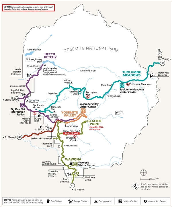
Yosemite Gude
The Yosemite Gude is the monthly newsletter published by National Park Services. The newsletter is an invaluable resource for learning about current changes, events, and closures.
Don’t drive to Yosemite National Park before downloading and checking the latest issue.
For example, let’s see what we can learn from the issue of Yosemite Gude I included below. It is dated July-August 2022.
- In the summer of 2022, you can not enter Yosemite from 6 am to 4 pm without reservation.
- The following campgrounds are closed: Bridalveil Creek, Crane Flat, Porcupine Flat, and Toulumne Medows.
- The Glacier Point Road is closed.
- The Glacier Point is closed for the entire 2022 year.
Yosemite National Park Hiking Maps (PDF)
If you’re looking for the best way to see all that Yosemite National Park has to offer, hiking is the answer. There are trails for all levels of hikers, from beginner to experienced. You can choose a short, easy hike that will show you some of the park’s most famous sights or a longer, more challenging hike that will take you into the backcountry. No matter what route you choose, you’re sure to see some of the most beautiful scenery in the world.
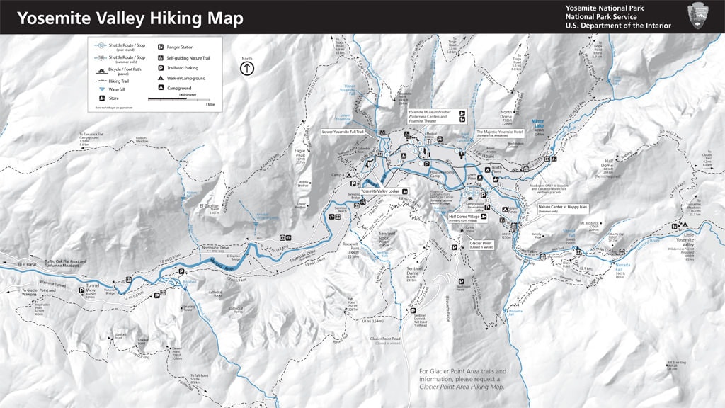
Yosemite Valley Hiking Map
The Yosemite Valley Hiking Map is an excellent resource for hikers who want to explore the valley. The map shows all of the area’s major trails, points of interest, parking areas, and campgrounds. It is also marked with elevations, so hikers can choose a trail that matches their skill level.
Glacier Point Area Hiking Map
Glacier Point is a breathtaking viewpoint located on the south wall of Yosemite Valley at an elevation of 7,214 feet (2,199 m). The point offers stunning views of Half Dome, Vernal and Fall Creeks, and the Merced River Valley. From Glacier Point, it’s easy to access trails that lead down to the valley floor or various hikes along the rim.
The map includes information on where to find parking and the location of trails, waterfalls, and other points of interest. The map also includes a handy elevation profile, which can help you to plan your trip based on how challenging you want your hike to be.

Wawona Area Hiking Map
The Wawona region of Yosemite is located in the southwest corner of Yosemite National Park and is the most popular destination in Yosemite National Park after the valley.
The Wawona region of Yosemite is famous for its sequoia grove rather than the massive mountainous scenery found in the rest of the park. Mariposa Grove is home to over 500 mature sequoias, the largest tree in the world by volume.
The Mariposa Grove of Yosemite National Park is a beautiful area that offers visitors a unique natural experience different from the rest of the park.

Tuolumne Meadows Hiking Map
The Tuolumne Meadows region of Yosemite National Park is a pristine alpine area with elevations ranging from 8,000 to nearly 12,000 feet that offers visitors stunning views of the Sierra Nevada mountain range. The Meadows are famous for their wildflowers, which bloom during the summer months.
The area is well known for its excellent hiking, backpacking trails, fishing, and camping opportunities.
You access Tuolumne Meadows from Tioga Road, Yosemite’s east entrance.

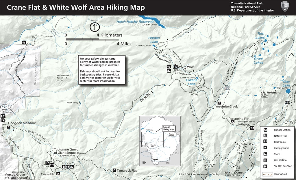
Crane Flat & White Wolf Hiking Map (PDF)
Yosemite Campgrounds Map
The best way to explore Yosemite National Park is by staying in campgrounds.
The park has 13 campgrounds, which can accommodate tents, RVs, and trailers. The campgrounds are spread throughout the park and range from primitive to modern. There are also a number of backcountry campsites available for those who want to get away from it all.
The following map provides an overview of the campgrounds in Yosemite.
Please note that the featured map shows only 10 campgrounds, the rest is located in the Yosemite Valley, and you need to use the valley map to find them.
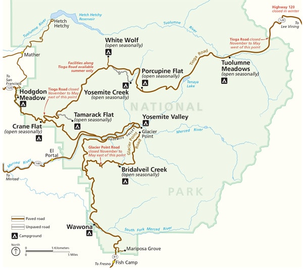
Yosemite Winter Trails Maps (PDF)
If you are planning a ski or snowshoe tour in Yosemite, there are a few things you need to know to make sure your trip is a magnificent experience:
- Check the weather and avalanche conditions before you go. Yosemite can have some of the harshest weather conditions in the country, so it is essential to be prepared.
- Make sure you are familiar with the terrain. There are many different types of terrain in Yosemite, from open meadows to cliffs, so it is essential to know what you are getting into.
- Be prepared for anything.
Even though the odds of having an emergency are slim, it is always best to be prepared just in case.
Badger Pass Ski Area and Glacier Point Road Map

Crane Flat Map Winter Trails Map
The Yosemite National Park Crane Flat Winter Trails are a great way to experience the park in the winter. The trails are tailored for cross-country skiing and snowshoeing at all skill levels.

Where is Yosemite National Park?
Yosemite National Park is one of the most beautiful and visited parks in the United States. It is located in eastern California in the Sierra Nevada mountains. The mountain range extends over 400 miles and includes some of North America’s highest and most rugged mountains.
Yosemite National Park Address
Yosemite National Park Address: Tioga Rd Hwy 120 & Hwy 140 Yosemite National Park, CA 95389
Yosemite National Park Facts
Yosemite National Park is a national park located in the Sierra Nevada of California, USA. The park was established in 1890 and covered an area of 1,145 square miles. It was designated a UNESCO World Heritage Site in 1984 because of its natural beauty and unique geological features.
The park is home to more than 3,000 plant species, 400 animal species, and over 100 geological features. The park has more than 160 hiking trails that lead visitors through the park’s forests, meadows, and granite cliffs.
- Yosemite National Park was established on October 1, 1890
- Over 3 million people visit the park every year
- 75%of visitors come between May and October
- Yosemite Falls is the highest waterfall in the United States
- Yosemite is the rare place where you can see a rainbow (moonbows) at night
- Glaciers formed Yosemite Valley
- 500 Giant Sequoias call Yosemite their home
- Yosemite has more than 800 miles of trails
- Yosemite elevation levels range from 2,000 (610m) feet to over 13,000 (3960m) feet.
- Yosemite is the only National Park to have bid for the Olympics (1932)
Weather In Yosemite National Park
The Yosemite National Park had a climate that is known as “Mideterrian.” The summers are hot and dry, while the winters are cold and snowy.
Yosemite experiences all four seasons, and most of the precipitation occurs during the winter months. During Spring, Summer, and Fall, Yosemite encounters less than 5% of annual rainfall.
But you have to remember that Yosemite is located in the Sierra mountain range with elevation levels between 2,000 (610m) and 13,000 (3960m) feet. That makes the weather in Yosemite National Park unpredictable. The temperature can change rapidly from one extreme to another. You can experience all four seasons in a single day.
Visitors to the park should be prepared for all types of weather.
The Closest Airports to Yosemite
Fresno Yosemite International Airport (FAT)
- Distance to Yosemite: 95 miles
- Drive time: 2.5 hours
San Francisco International Airport (SFO)
- Distance to Yosemite: 178 miles
- Drive time: 4-4.5 hours
San Jose Mineta International Airport (SJC)
Distance to Yosemite: 178 miles
Drive time: 4-4.5 hours
Oakland International Airport (OAK)
- Distance to Yosemite: 180 miles
- Drive time: 4-4.5 hours
Reno Airport (RNA)
Distance to Yosemite: 213 miles
Drive time: 4.5 hours
Las Vegas McCarran International Airport
Distance to Yosemite: 420 miles
Drive time: 7.5 hours
Consider Detailed Topographic Map for Yosemite
If you plan extensive hiking and backpacking in Yosemite, I highly recommend getting a professional-grade topographic map from National Geographic.
Every Trails Illustrated map is printed on “Backcountry Tough” waterproof, tear-resistant paper. An entire UTM grid is published on the map to aid GPS navigation.
Yosemite National Park Map | Final Thoughts
A trip to Yosemite National Park is a true undertaking that takes time and effort. I hope my Yosemite maps will help you with planning and make the journey more enjoyable.