

Gatlinburg is the best place to stay in Tennessee if you enjoy chasing waterfalls. Almost a dozen waterfalls are within a 30-minute drive of the mountain town. It’s more than enough to keep you busy for a week or more – or multiple trips.
All the waterfalls near Gatlinburg are in the Great Smoky Mountains National Park. This adds a layer of difficulty in visiting the waterfalls. You’ll need to purchase a parking tag, plan your trip around peak tourism times, and hunt for parking at the trailheads.
It’s not mission impossible – but it’s not a cakewalk.
Use this guide to the waterfalls in Gatlinburg to learn about the waterfalls, where to park, the hiking trails to the falls, and the best times to visit.
Note | The waterfalls in this guide are listed from east to west to make it easier to find on the map.
Missing Waterfalls
You may read this guide and immediately, “What about Abrams Falls? How could he forget this waterfall?!”
I didn’t forget. I left them off this list. And for good reason.
Abrams Falls is one of the best waterfalls in the Great Smoky Mountains National Park. But the trailhead to the waterfall is at the far end of Cades Cove. On a good day, driving from Gatlinburg to the Abrams Falls Trailhead takes over an hour. And on a busy day, it can take 2-3 hours – each way.
If you want to visit Abrams Falls, I recommend spending two nights in Townsend. It’s a quiet town that capitalizes on mountain peacefulness.
There are 17 waterfalls in the Great Smoky Mountains National Park. And in North Carolina, there are a few waterfalls outside the park in Cherokee. Sometimes, the best place to stay to chase waterfalls is Townsend, Bryson City, or Cherokee.
Map of Waterfalls in Gatlinburg
How to use this map | Click the icon in the top-left corner to open the Map Legend, then click on any of the legend items to display more information. If you have a Google account, click the (very faint) star at the end of the map’s name to save this map to your account, then access the map from your smartphone during your trip.

Best Time to Visit Waterfalls
Spring is always the best time to visit waterfalls, and there’s no exception in Gatlinburg. March is the wettest month of the year with 4” of rainfall. But April and May are close seconds with 3.9” and 3.6”, respectively.
All this rain is excellent for visiting waterfalls. Some waterfalls, like Abrams Creek, have enough water volume to be great all year. But other waterfalls, like Grotto Falls and the Place of a Thousand Drips, are better to see after heavy rainfall.
The best time to visit most waterfalls near Gatlinburg is April or May. The worst time to visit any of the waterfalls is October. Although the spectacular fall colors are a stunning addition to the scenery, it’s the driest month of the year, and many waterfalls are reduced to a trickle.
Another factor to consider is the traffic in the Great Smoky Mountains National Park. June, July, and October are the busiest months of the year, totaling nearly 6 million visitors – almost half the annual visitors. But May is part of the shoulder season with barely half as many visitors as the more popular months.
Ramsey Cascades
Ramsay Cascades is not the most popular waterfall. It’s not even in the top five most popular in Great Smoky Mountains National Park. But it is the tallest.
The 100-foot cascading waterfall is located near the Greenbrier area, about half an hour from Gatlinburg. The 8-mile roundtrip hike on the Ramsey Cascades begins at a small parking lot at the end of the dirt road. The trail follows the creek upstream to the waterfall with a gradual 2,185-foot ascent.
Read More: AllTrails App Review – Why AllTrails is the Best Hiking App
It’s a moderately strenuous hike with a steady climb to the waterfall. But it’s a downhill trek back to the car after seeing the spectacular waterfall. A small pool at the bottom is perfect for getting your feet wet. It takes about 5-7 hours to complete the trail.
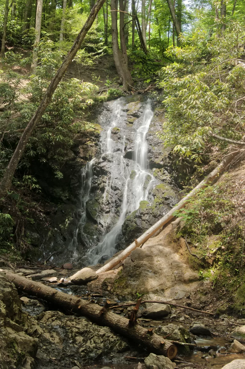
Fern Branch Falls
After a gentle walk along the Porters Creek Trail, the cascading 35-foot Fern Branch Falls is a treat. It’s one of the least visited waterfalls in the Great Smoky Mountains National Park and rarely appears in travel guides or maps. I found it by accident after learning about a CCC cabin along the trail – I missed the cabin but found the waterfall.
The 7-mile roundtrip hike on the Porters Creek Trail is one of the easiest in the national park. The trail has a gradual 1,500-foot ascent from the parking area, following an old logging road that’s flat and well-maintained.
Fern Branch Falls is on the right side of the trail, about 1.7 miles from the parking area. It takes about 30 minutes to hike to the waterfall casually. And it’s a downhill hike on the way back.

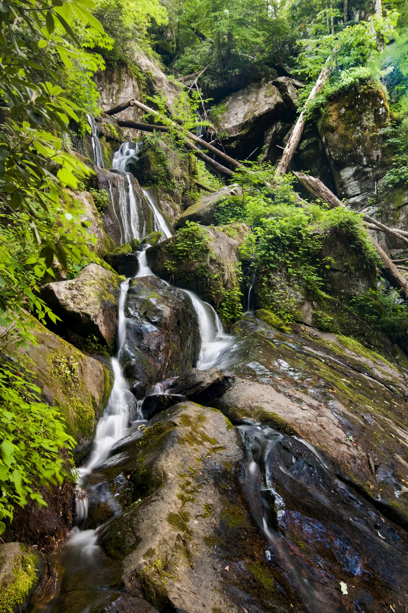
Place of a Thousand Drips
The Place of a Thousand Drips is a curious waterfall. On most days, especially in late spring and autumn, the waterfall is reduced to dozens of tiny streams and hundreds of drips.
But after heavy rainfall, more than a dozen streams of water cascade along the jagged rocks and smooth boulders.
The Places of a Thousand Drips is near the end of the Roaring Fork Motor Nature Trail, a one-lane, one-way scenic drive near Gatlinburg. There is limited parking around the waterfall. Drive past the waterfall for a few pull-off parking spots along the road and walk back to see it.
But most people stop in the road for a moment to admire the waterfall – it’s one of only two waterfalls in the national park viewable from the car.
Baskins Creek Falls
Baskins Creek Falls is a 40-foot cascading waterfall in the center of the Roaring Fork Motor Nature Trail. It’s grown in popularity recently as other waterfalls have become overcrowded.
Baskins Creek Trail crosses from one side of the Roaring Fork Motor Nature Trail to the other, providing two ways to hike to Baskin Creek Falls.
Read More | Travel Guide to the Roaring Fork Motor Nature Trail at Great Smoky Mountains National Park
The first trailhead is a few hundred feet from where the one-lane, one-way road begins. But you don’t have to commit to the auto touring route. You can park at the Rainbow Falls Overflow Lot on Cherokee Orchard Road before turning onto the Roaring Fork Motor Nature Trail and then walk along the road to the trailhead.
From this trailhead, the waterfall is about 1.4 miles into the rugged terrain. It’s a moderately easy hike with a gentle elevation gain.
Pro Travel Tip | The best place to park to hike this trail in the summer is the Rainbow Falls Overflow Parking – and early in the day. The one-lane, one-way scenic road is often overcrowded with bumper-to-bumper traffic in the summer and in October.
The second trailhead is on the opposite side of the Roaring Fork Motor Nature Trail near the Alex Cole Cabin. From here, the 1.3-mile hike to the waterfall is slightly more challenging.
- Best Time to Visit | April or May, or just after sunrise in the summer.
- Address & Map | Baskins Creek Trail, Gatlinburg, TN 37738
- Parking | Pull-off parking along the Roaring Fork Motor Nature Trail at either the trailhead or the Rainbow Falls Overflow Parking on Cherokee Orchard Road.


Grotto Falls
Grotto Falls is tiny, but it’s spectacular. The 25-foot-tall waterfall spills over a rocky outcropping into a shallow pool. It’s a popular waterfall located on a popular hiking trail with multiple destinations, so it can become a busy place during the prime season.
The waterfall’s trailhead is located on the Roaring Fork Motor Nature Trail, a 5-mile one-lane, one-way scenic drive in Gatlinburg. Begin on Historic Nature Trail and then continue onto Cherokee Orchard Road to the gate at the beginning of the one-lane portion of the scenic drive. Continue to a parking area along the road. There are few marked parking spaces near the two trailheads, but you’ll find more as you continue along the road. A privy restroom is available between the two trailheads.
The hike to Grotto Falls follows a 2.6-mile roundtrip journey on the Trillium Gap Trail. It’s a moderately difficult hike with a 544-foot ascent to the waterfall – but fortunately, it’s downhill coming back. The hike takes about 2-3 hours.
Read More: AllTrails App Review – Why AllTrails is the Best Hiking App
Rainbow Falls
Rainbow Falls is one of the most popular waterfalls in Great Smoky Mountains National Park, routinely competing with Laurel Falls and Abrams Falls for most visitors. The 80-foot freefalling waterfall crashes into a shallow pool and then trickles through a series of small crevasses in the rock-strewn stream below.
The trailhead is on Cherokee Orchard Road before entering the Roaring Fork Motor Nature Trail, which is why it’s a popular hiking trail. There are two large parking lots – one located at the trailhead and the other beside the entrance to the motor nature trail. There are also a few pull-off parking spots along the road. There is a privy restroom in the first parking lot.
The 5.1-mile roundtrip hike on the Rainbow Falls is moderately difficult, with a gentle 1,600-foot ascent. It’s a steady upward climb alongside LeConte Creek to the waterfall – so it’s a pleasant downhill trek on the way back. The hike takes about 2-3 hours to finish.
- Best Time to Visit | April or May, or mid-week in the summer or October.
- AllTrails | Rainbow Falls Trail
- Address & Map | Rainbow Falls Trail, Gatlinburg, TN 37738
- Parking | There are dozens of parking spaces along the road before and after the trailhead and an overflow parking lot two minutes past the trailhead.
Cataract Falls
Cataract Falls is one of the least spectacular waterfalls in the Great Smoky Mountains National Park. But the trailhead begins at the most popular visitor center and is an effortless hike.
The 25-foot cascading waterfall is typically reduced to thin streams of water softly falling into a shallow pool. But, after heavy rainfall, the waterfall features a tremendous water flow.
The trail begins between the Sugarlands Visitor Center and restrooms. Follow the signs because several trails intersect and branch off in different directions. It takes about 20 minutes to walk the 1.1-mile trail casually.
Huskey Branch Falls
There are a lot of things to do in the Elkmont Historic District. You could explore the restored cabins in Daisy Town. Take a walk along Millionaires’ Row. Or go for a pleasant hike to Huskey Branch Falls.
I think the Little River Trail is one of the best hiking trails in the Great Smoky Mountains National Park. The trail follows the course of the small river, providing hikers with a constant hum of rushing water.
Pro Travel Tip | You’ll find restrooms at the Elkmont Campground. It’s best to visit the restrooms before parking near the trailhead.
The 4.3-mile out-and-back hike on the Little River Trail features a gradual ascent of about 350 feet. It takes about 90 minutes to hike the trail but give yourself time to enjoy the scenery along the way.
One of the reasons I love this trail is the fascinating remnants of previous cabins and the troll bridge! A stone fireplace is all that remains of a cabin, stubbornly standing in the middle of the forest. The Troll Bridge is a gorgeous stone bridge where the Little River Trail crosses a creek.
- Best Time to Visit | April or May
- AllTrails | Little River Trail
- Address & Map | 603 Little River Trl, Gatlinburg, TN 37738
- Parking | A few parking spaces at the trailhead near the Spence Cabin. If those spaces are taken, continue driving around the corner to a larger parking lot at the Jakes Creek Trailhead.

Laurel Falls
Laurel Falls is a beautiful 80-foot-tall cascading waterfall and one of the most popular waterfall hikes in Great Smoky Mountains National Park. The trailhead is only 6 miles from Gatlinburg – one of the primary reasons it’s such a popular trail.
It’s a 2.6-mile roundtrip hike to the waterfall on the Laurel Falls and typically takes about two hours. The moderate trail has a gradual ascent to the waterfall. It’s a deceiving trail because it starts paved, but the pavement quickly succumbs to nature. The trail is well-maintained but wonderfully rough. Mountain streams cross the trail in several places.
Read More: AllTrails App Review – Why AllTrails is the Best Hiking App
The waterfall is divided into an upper and lower section. A walkway cuts across the middle, allowing visitors to get closer to this waterfall than any other in the national park. With overcrowding reduced, there’s plenty of room to enjoy the spectacle if you bring a lightweight camp chair or hammock.
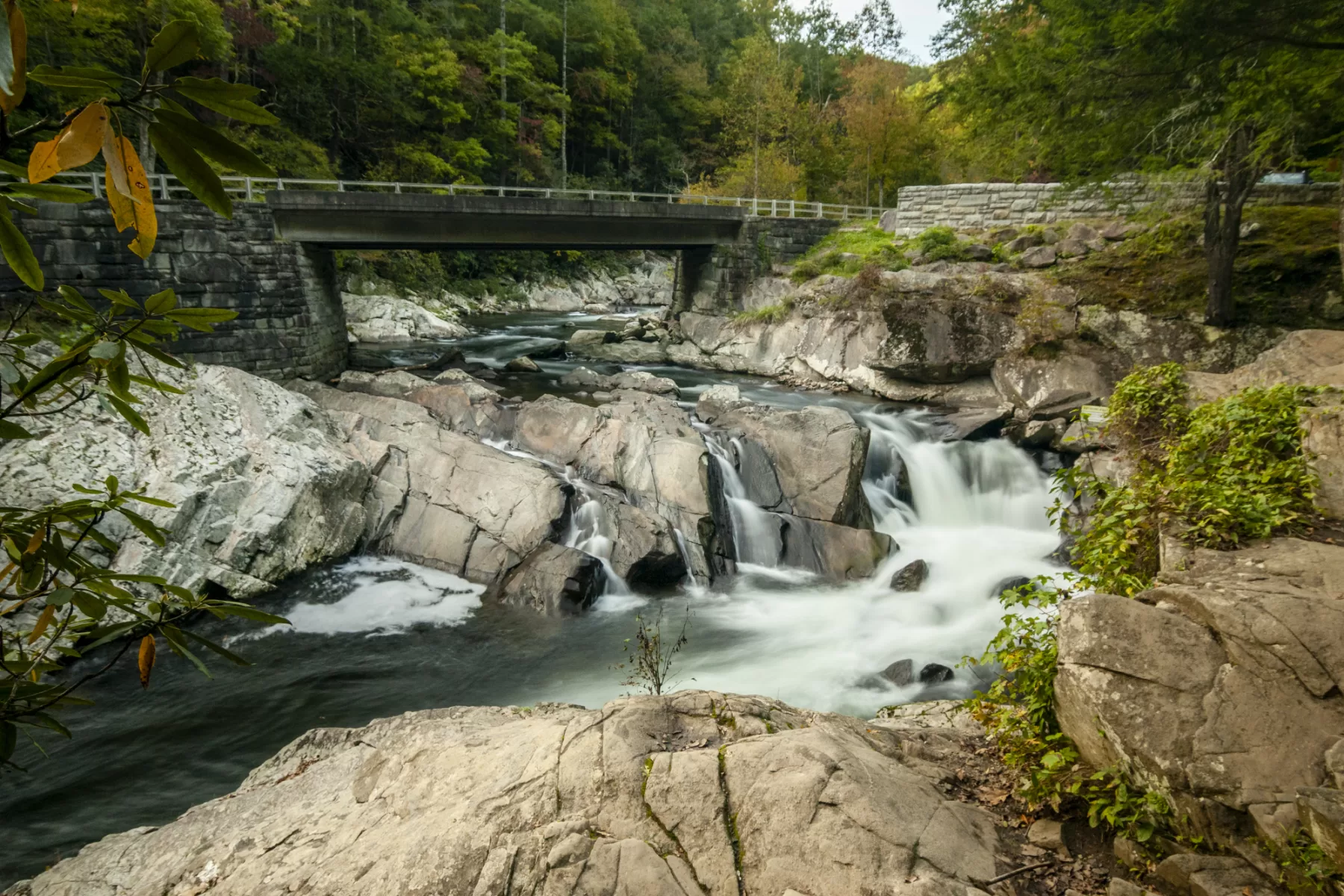
The Sinks
Logging was the primary industry in the Great Smoky Mountains throughout the 1800s. Before the first railroads were built to haul the timber out of the forest, they were floated along the Little River. But in the last years of floating logs, heavy rainfall left a massive pile of hundreds of logs stuck in the horseshoe bend of the river.
Workers decided to use dynamite to free the log jam. But the tremendous explosion did more than clear the stuck logs on the river. It created a 30-foot-deep chasm in the riverbed and bridged two ends of the horseshoe bend, rerouting the river.
Read More | The Fascinating Story of How Dynamite Created The Sinks at Great Smoky Mountains National Park
Today, the interesting place is called The Sinks. It’s about ten miles from Townsend and fifteen miles from Gatlinburg on Little River Road. A bridge crosses the turbulent rapids as the river gushes across the jagged rocks. It’s a popular place for fishing, but swimming is prohibited because of the powerful river currents.


Meigs Falls
Meigs Falls is one of only two Great Smoky Mountains National Park waterfalls that can be seen from the comfort of your car. Meigs Creek plummets into a narrow cove before flowing into the Little River.
Although the waterfall is about 30 feet tall and 60 feet wide, with a good flow throughout the year, it’s difficult to see. The waterfall is set back from the highway about 500 feet across the Little River. A pull-off parking area offers plenty of room for vehicles – typically, people inch along the parking area to enjoy the view from the car and then leave just as quickly as they arrived.
The waterfall is about 15 miles from Gatlinburg and 7 miles from Townsend on Little River Road. The best way to see this waterfall is with a good pair of binoculars.
- Best Time to Visit | April or May. But it’s also spectacular when frozen over in the winter.
- Address & Map | Townsend, TN 37882
- Parking | Several pull-off parking spaces on the waterfall side of the two-lane road.