


Owls Head Mountain is a 4000-footer located deep in the Pemigewasset Wilderness. While you can hike out and back to it in a long 16-18 mile day, I had a hankering to turn it into a casual backpacking trip for a chance to sleep outside at least one more time before the onset of winter, which could arrive any day now. While I do plan to do some above-treeline backpacking this winter in the Presidentials, that is a completely different experience from sleeping down low in the bosom of the Pemi.
Now that we’re past Columbus Day (October 10), the White Mountain National Forest takes on a very different appearance. Things that were hidden from sight by leaves and understory vegetation are suddenly revealed, giving the forest a completely different appearance; a renewal of sorts, before the long winter sets in.
People who hike the 4000-footers all year round will tell you that it’s fun to experience the same trails in different seasons because you see different things. While I’ve discounted that somewhat in my own experience, and I try to vary the trails I follow to the high peaks, this autumn has been different. I really am noticing and finding new aspects of the forest that I haven’t ever experienced.

Route
There is a pretty standard route that most hikers take out to Owls Head these days, although there are multiple ways to reach the peak. For this hike, I followed the most popular route:
- Lincoln Woods Trail – 2.6 miles
- Black Pond Trail – 0.8 miles
- Black Pond Bushwhack – 1.0 miles
- Lincoln Brook Traill – 2 miles
- Brutus Bushwhack – 0.6 miles (up)
- Owls Head Path – 0.6 miles (up)
- Owls Head Path – 0.6 miles (down)
- Brutus Bushwhack – 0.6 miles (down)
- Lincoln Brook Trail – 2 miles
- Black Pond Bushwhack – 1.0 miles
- Black Pond Trail – 0.8 miles
- Lincoln Woods Trail – 2.6 miles
Those bushwhacks, listed above, let you avoid several stream crossings and an avalanche slide which can be problematic when the weather gets colder. There’s been a lot of controversy in recent years about these “bushwhacks” which are now quite well defined, but still unofficial trails. I’d estimate that 90% of the hundreds of hikers going out to Owls Head follow them and there’s little point in banning their use since everyone uses GPS apps, like GaiaGPS and AllTrails, to follow them.
It was different when only a few guides knew the routes and the level of traffic was far lower. But there is no point in trying to ban their use at this point. Unfortunately, GPS apps and social media have made our world a much smaller place. The cat is out of the bag and it is impossible to put it back in.

Trip
I headed up the Lincoln Woods trail which was very pretty with the autumn color and turned onto the Black Pond Trail. From there it’s about 0.8 miles to the start of the unofficial Black Pond Bushwhack, which avoids the two major water crossings required to reach the Lincoln Brook Trail, which runs to the base of Owls Head. This was the 5th time I’ve hiked out to Owls Head this year, so I have a decent idea of what to expect.
There are two more water crossings you need to contend with right before the climb up Owls Head. In warmer weather, I don’t care about getting my shoes wet in any of these crossings, but when nighttime temperatures drop below freezing, as they have for several weeks now, I avoid getting my trail runners wet. So for those 2 crossings, I carried a pair of Wiggy’s Waders to keep my feet dry, although I didn’t end up needing them because both were low enough to rock hop.

While the Black Pond Bushwhack is an unofficial herd path at this point, the route it takes through the forest does fluctuate a bit, particularly in winter it follows the route that the last person to break it out (compress the snow with snowshoes) took. The first half of the route was different than the last time I hiked it in June, although the second half coincided perfectly. The route was also heavily obscured by leaf litter, but I’m very good at following badly defined trails so I didn’t have any problems figuring out the current “route.” I was still equipped with a compass, map, and GaiaGPS though.
The bushwhack comes out on the Lincoln Brook Trail, just after the second river crossing, which it bypasses. From there I hiked up the very wet LBT, trying to keep my mesh trail runners dry. The mesh trail runners I use, Saucony Peregrine 11’s (last year’s model) have a sock liner inside which I find wards off wet feet to a certain extent. Of course, it does nothing for the durability of the external mesh which gets destroyed after about 200 miles of White Mountain hiking. I’m seriously considering moving to a more durable hiking shoe because I am sick of replacing mesh trail runners at $150-$200 a pop. There has to be a better way.
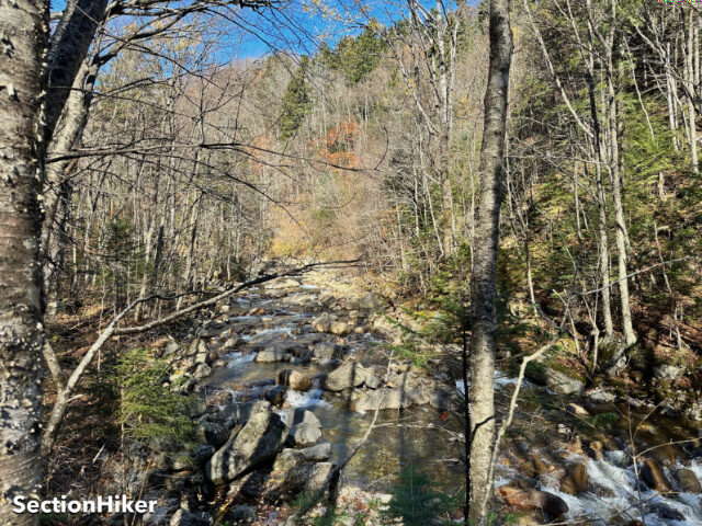
The Lincoln Brook Trail is always wet, at least when it’s not covered in ice. Despite this I made good time, hopping skipping, and jumping to avoid the mud pits and puddles along the way. The trail runs alongside Lincoln Brook which is still running very low because of the summer drought, even though we’ve had a lot of rain in the past month.
Since I had a full pack, I found a hidden campsite to stash my heaviest gear while I climbed the peak. Some people leave their packs at the base of the Owls Head climb and climb without one, but I prefer carrying a minimum of safety gear with me when I climb summits. You just never know when you’ll need it.

I climbed Owl Head using the Brutus bushwhack, instead of going up the avalanche slide which is another route. That route, which again is now a well-established herd path, is named after Brutus, a Bernese Mountain Dog who couldn’t get up the avalanche slide, which is basically a rocky shute that climbs about 1000 feet. That’s another 600 feet of elevation gain above that, but it’s at least a trail. This bushwhack route was created so Brutus could get to the summit. He is no longer with us but his herd path lives on.
Up I went, following the summit ridge to the mountain highpoint, marked by a small cairn. I took a few photos, turned around, and reversed my route, hiking back to my gear stashed in the woods.

It was still mid-afternoon, so I decided to hike back out partway and find a stealthy campsite for the night instead of staying at the one I’d found closer to the peak. This proved harder than I expected because there isn’t a lot of level ground between the end of the Black Pond bushwhack and the Owls Head Path. But I found a nice site eventually, pre-existing in this case – and set up camp, made dinner, hung my Ursack, got into my sleeping bag, and fell asleep for the next 14 hours. I like sleeping outside. I could have made it back to the start of the hike before sundown, but one of my chief goals for this hike was to camp out.

I made tea the next morning, but the ProBar I’d packed for breakfast was frozen, so I had to defrost it by dipping it the hot water. Then I packed up and hiked out.
This was the last 4000-footer I needed to climb in October for the 4000 Footer Grid (12 x 48), bringing my total to 478 summits. With 98 peaks left, there’s still a lot of adventure left.
Recommended Guidebooks and Maps:
SectionHiker is reader-supported. We independently research, test, and rate the best products. We only make money if you purchase a product through our affiliate links. Help us continue to test and write unsponsored and independent gear reviews, beginner FAQs, and free hiking guides.