
Ok… so you got your John Muir Trail permit, planned your resupply points, and got your gear lined up. Congrats! You’re almost ready for the best backpacking trip of your life. But don’t lace up those boots just yet… you still have a few more logistics to take care of, one of which is your John Muir Trail transportation plan.
John Muir Trail transportation is pretty simple if you have two cars and two people to drive. Simply drop one car off at one end, drive the other up to your permitted trailhead, and after your hike run a shuttle back up to your starting point.
But what if you are going solo, don’t have two cars, or are flying in from somewhere far away? Then you’ll want to take public transportation to the John Muir Trail, and you have 3 major decisions to make:
- What direction to hike
- What airport to fly into
- How to get to & from your John Muir trailhead
In my John Muir Trail Transportation Guide, you’ll find all of the information you need to plan your public transportation logistics for your John Muir Trail hike.
And as it goes in all of the destinations we share, please practice good trail etiquette and remember to Leave No Trace. This means packing out all of your garbage, being respectful to others on busy trails, and following the established rules.
Step 1: What Direction to Hike the John Muir Trail
The 212-mile John Muir Trail runs from Yosemite to the Whitney Portal trailhead just south of the 14,505’ Mt. Whitney. The most popular direction for John Muir Trail hikers is North to South because you are able to adjust to the altitude more gradually (the passes and peaks get taller as you move south towards Mt. Whitney).
If the acclimatizing advantages don’t sell you on a North to South JMT hike, public transit and parking are also easier in Yosemite, and you also have the opportunity to explore the park before and after the hike if you have extra time.
On the other hand, southbound John Muir Trail permits are becoming harder to come by, so many people are opting for a northbound John Muir hike departing from Horseshoe Meadow, just south of Whitney. Horseshoe Meadow is not accessible by public transportation, but I have heard about a private shuttle from Lone Pine to Horseshoe Meadow run by Kurt Power. I haven’t used him myself, so I can’t speak to the experience, but his contact info is 760-876-4811 or LonePineKurt@aol.com.
Step 2: Decide What Airport to Fly Into
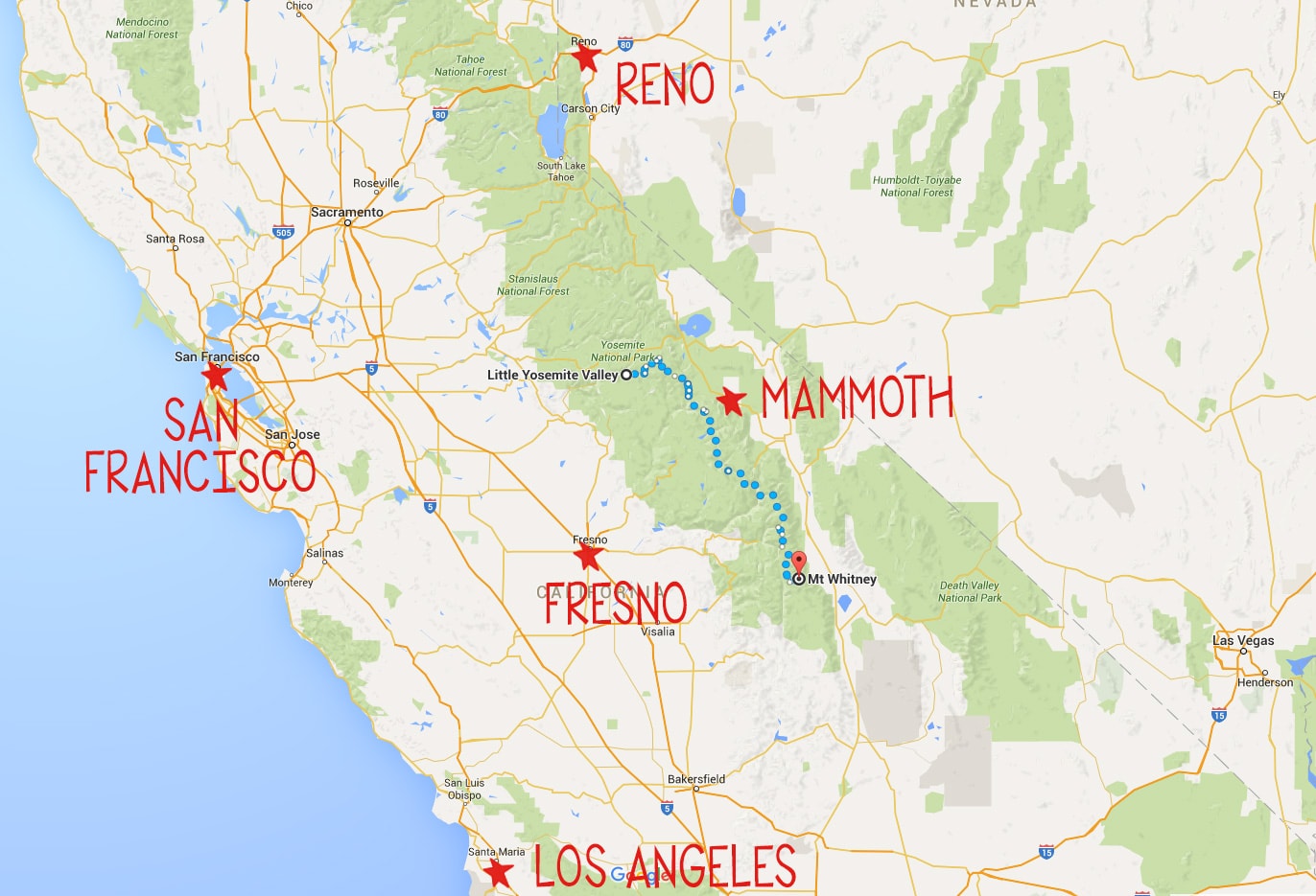
Mammoth
If you don’t live out west and you plan on flying into California to start your hike, the easiest airport to fly into is the Mammoth airport. Conveniently situated on the eastern side of the Sierras between Yosemite and Mt. Whitney on Highway 395, there is frequent public transportation that you can use to get to and from the JMT. What’s more, Alaska Airlines and United serve this airport, so you can pretty much get to Mammoth no matter where you are coming from. The only downside to Mammoth is that fares can be a bit more expensive than larger airports, but you’ll make up for it in convenience.
Reno
The second best option is the Reno airport. However, getting to Yosemite from Reno requires a transfer in Mammoth, and Reno is several hours further from the endpoint at Mt. Whitney (assuming you are hiking north to south) than Mammoth.
San Francisco, Oakland, or Los Angeles
Major airports on the west side of the Sierras – like San Francisco, Oakland, or Los Angeles – may have cheaper flights, but they are substantially more difficult to get back to since you will finish your hike on the east side of the Sierras, requiring a very long drive around to the other side. Amtrak connects to YARTS (more on YARTS below) in Merced if you want to look at train/bus options.
I’m not going to detail these routes since they require multiple transfers between trains and buses. If you want to fly into one of these airports, Rome2Rio is a helpful public transportation planning tool that you can use to figure out the best route from SFO, OAK, or LAX.
Regional Airports
Other regional airports like Fresno-Yosemite or Merced don’t offer the same convenient transit options and also aren’t any cheaper.
All airports (Mammoth, Fresno, and Merced included) have car rentals available if you want to rent a car… but leaving a rental car at a trailhead for 2-3 weeks doesn’t seem that economical.
Step 3: How to Get to & from the John Muir Trail using Public Transportation
From Mammoth Airport:
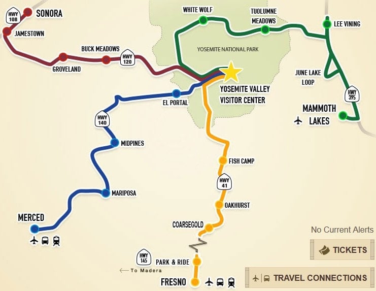
If you are going to fly round trip to the Mammoth Yosemite Airport, then public transit is a great, easy, and cheap way to get to the JMT and back to the airport at the end. Just take a taxi into Mammoth Lakes, where you can pick up the Yosemite Area Regional Transit (YARTS) HWY 120/395 bus from Mammoth to Yosemite Valley (the line shown in GREEN on the map below). The bus runs daily in July and August and you can get dropped off either in Tuolumne Meadows or Yosemite Valley, depending on which trailhead you have a permit for. If you go all the way to Yosemite Valley, the bus ride takes 4 hours.
Getting back to the Mammoth Airport: At the south end of the John Muir Trail, you exit at the Whitney Portal trailhead. There is no public transportation that goes directly to the trailhead, so you’ll need to hitchhike out to the nearest town of Lone Pine. It’s about a 20-minute ride, and with all the people hiking to the Whitney summit every day, hitching a ride is common practice and you shouldn’t have to wait that long. That said….always trust your gut and don’t get in the car with anyone you don’t feel comfortable with.
If you don’t want to hitchhike or you have a large group, the East Side Sierra Shuttle offers rides from the Whitney Portal to Lone Pine.
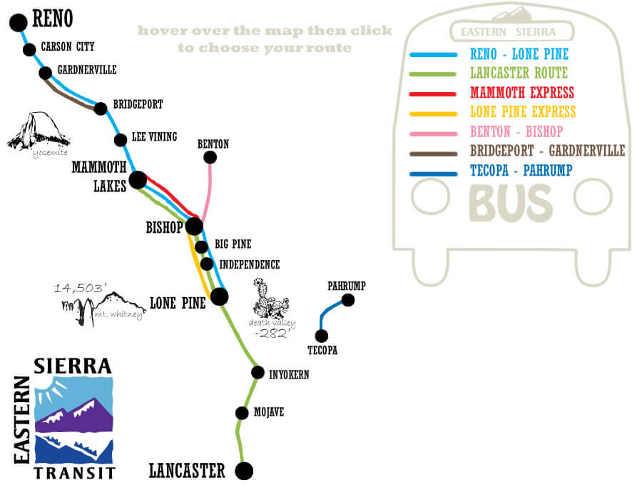
Once you are in Lone Pine, you can take a 2-hour Eastern Sierra Transit bus back to Mammoth, and there are two different lines that will get you there:
- The Lone Pine-Reno line leaves Lone Pine at 6:15am, Monday, Tuesday, Thursday, and Friday
- The Lancaster Route leaves at 5pm, and runs Monday, Wednesday, and Friday
- Unfortunately, there is no weekend bus service, so plan accordingly
- Reservations are also recommended. Call 800.922.1930 to reserve your seat
- Double check these times on their website, as schedules do change
If you want to skip the bus, East Side Sierra Shuttle will pick you up at the Mammoth Airport, drop you off in Yosemite, and then pick you up at Whitney Portal and take you back to the airport. This is an awesome (but expensive) way to take the hassle out of the travel, especially if you have a bigger group.
From Reno Airport:
Getting to the John Muir Trail: If you are starting in Yosemite, you’ll need to take a 4-hour Eastern Sierra Transit bus from Reno and get off in Lee Vining or Mammoth. Mammoth is the last “major” town to get last-minute supplies such as gear and backpacking food, so if you think you need to pick anything up, plan on stopping in Mammoth.
Then once you are in Lee Vining or Mammoth, transfer to the Yosemite Area Regional Transit (YARTS) HWY 120/395 bus. As mentioned above, the YARTS bus runs daily in July and August and you can get dropped off either in Tuolumne Meadows or Yosemite Valley, depending on which trailhead you have a permit for. If you go all the way to Yosemite Valley, the bus ride takes 4 hours.
Getting back to the Reno Airport: Once you are in Lone Pine, you can take a 6-hour Eastern Sierra Transit bus all the way to Reno.
- The Lone Pine-Reno line leaves Lone Pine at 6:15am, Monday, Tuesday, Thursday, and Friday.
- Unfortunately, there is no weekend bus service, so plan accordingly.
- Reservations are also recommended. Call 800.922.1930 to reserve your seat.
- Double check these times on their website, as schedules do change
Parking Options for the John Muir Trail
Another option if you have only one car is to park it at one end and then take public transportation to the other end. But where do you leave your car? Fortunately, there is long-term parking available in Yosemite and the Whitney Portal.
Yosemite
There is free long-term parking available near the Happy Isles trailhead at Curry Village and at Tuolumne Meadows in the Wilderness Permit lot. Make sure to check in first before parking and if you have any questions about parking, just ask the ranger. Also, make sure you don’t leave any food in your car, and instead place any scented items in the parking lot bear lockers.
Whitney Portal
When I did the John Muir Trail, you were allowed to leave a car in the parking lot up at the Whitney Portal, although the lot does fill up and you may need to wait for a spot. For more information on current road conditions up to the Whitney Portal, visit the Inyo National Forest website.
What questions do you have about John Muir Trail transportation? And if you’ve hiked the JMT, leave any tips in the comments below!