
Everything you need to know about West Valley Fault Line.
The “Big One,” which experts say may happen in our lifetime, could strike once the West Valley Fault moves.
WHAT IS WEST VALLEY FAULT?

And when it did, it could generate a 7.2 magnitude earthquake causing great devastation of the most progressive portion of the Metro Manila.
Now, the danger is very imminent and every time a province along the stretch of this fault was hit badly by strong ground tremors, the fear of losing life and property aggravate the clamor on when the big one will happen. Fear and apprehension getting stronger particularly when tremors shook some parts of the country recently. On May 25, 2017, San Marcelino, Pampanga shook at 5.4 magnitude earthquake. This was also felt in Metro Manila, Cavite, Laguna, Rizal, Nueva Ecija, Pampanga, and Bataan.
Given these, there is a need to make the people understand what these events are all about so they will be better informed and they can prepare more and fear less.
EMERGENCY KIT AND ESSENTIALS
Here are the best options to shop for your emergency kit and life essentials:

IN THE PAST
In July 1990, the Central Philippine Fault moved and caused the 7.7 magnitude earthquake that wreaked havoc across Luzon. Baguio experienced the devastation that humbled almost everyone and seems made a realization: the fragility of the buildings that were built and how in a snap, human lives were snatched away.
In February 2006, after a 10-day continuous downpour, a minor movement of the same fault, a 2.6 magnitude earthquake tripped a saturated cliff of a ridge that caused a massive rock slide-debris avalanche burying the entire village of Guinsaugon, a township of St. Bernard in Southern Leyte.
More than a thousand death was recorded including the 247 children and 7 teachers who died when a school was entombed by the landslide.
THE IMPACTS
While Metro Manila is said to be the most developed place in the country, it appears to be the most dangerous and uninhabitable city when a catastrophic earthquake strike.
The affected cities and towns are as follows:
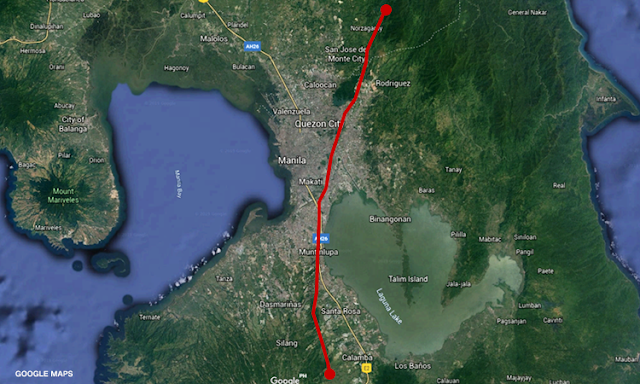
West Valley Fault
- Quezon City
- Marikina
- Makati
- Pasig
- Taguig
- Muntinlupa
- Bulacan (Doña Remedios Trinidad, Norzgaray, San Jose Del Monte City)
- Rizal (Rodriguez)
- Laguna (San Pedro City, Biñan, Sta Rosa, Cabuyao, Calamba)
- Cavite (Carmona, General Mariano Alvarez, Silang)
East Valley Fault
- Rodriguez, Rizal
- San Mateo, Rizal
 |
| West Valley Fault in Pasig |
If the West Valley Fault moves, the whole of Metro Manila will be affected in varying degrees. These areas may feel that up and down motion.
- Caloocan
- Las Pinas
- Malabon
- Makati
- Mandaluyong
- Manila
- Marikina
- Muntinlupa
- Navotas
- Paranaque
- Pasay
- Pasig
- Pateros
- Quezon City
- San Juan
- Taguig
- Valenzuela
Those living in provinces near the metro – such as Bulacan, Rizal, Cavite, and Laguna – may also feel the up and down motion.

The areas that will feel the strongest ground shaking (Intensity High 8 in the map), however, will not just be those near the fault itself, namely Marikina, Cainta, half of Taytay, Pateros, and Taguig.
The cities of Manila, Makati, Malabon, Pasay, and Caloocan, though relatively far from the actual fault line, will feel the same intensity levels as those near the fault line.
According to Solidum, this is because the foundation of those areas, especially Manila, are thick sediments that “amplify ground shaking.”
The Manila Cathedral, located within the Intramuros area in the city of Manila, has been destroyed by earthquakes multiple times because of this.
 |
| THE BIG ONE – West Valley Fault Line in Pasig City |
Of these, the study projected, residential buildings would sustain bulk of the damage from the earthquake. Details of damage projections below:
- Residential buildings – 339, 800 (25.6%) partly damaged; 168,300 (12.7%) heavily damaged
- Mid-rise buildings (10-30 stories) – 27% partly damaged, 11% heavily damaged
- High-rise buildings (30-60 stories) – 2% heavily damaged, 12% partly damaged
- Public-purpose buildings – 8-10% heavily damaged, 20-25% partly damaged
- The quality of construction and the type of building materials used play a big role in a building’s chances of surviving the earthquake, according to experts at Phivolcs.

In one of the plenary presentations of the 17th Science Council of Asia Conference, hosted by the National Research Council of the Philippines or https://www.morefunwithjuan.com/2020/03/list-of-cities-municipalities-in-metro.htmlin June 2017 at the Philippine International Convention Center, Dr. Renato U. Solidum, Jr., DOST Undersecretary for Disaster Risk Reduction and Climate Change Adaptation, said that when the West Valley Fault moved and generated a 7.2 magnitude earthquake, 34,000 people may die and will damage lifelines including water, infrastructure, roads, ports, and telecommunication.
The concentration of population in Metro Manila along with the various non-engineered and non-earthquake resilient infrastructures and buildings are causative factors.
There will also be a foreseeable chance that the whole country will undergo a state of economic paralysis as most government agencies and businesses are housed in buildings and infrastructures that overfilled the Metro Manila. These would mean a momentary hiatus in processes and transactions because of the most important economic arms are located in the Metro Manila.
Dr. Solidum is an active member of the NRCP Division of Earth and Space Sciences, which is mandated to conduct research studies on various natural phenomena to provide some scientific information clarifying the occurrences of these phenomena and their positive or negative impacts to human and the planet as a whole.
ATTRACTIONS TO SEE IN MANILA
A CALL FOR ACTION
Scenarios based on science, engineering, and experience should be used to approach head on the mitigation, preparedness, response, and recovery plans for the country in times of extreme disasters.
One of the components of the six (6) areas of basic research that will be prioritized by NRCP for 2017 – 2022 is on “all-systems risk modeling for Disaster Risk Reduction (DRR) and Climate Change Adaptation (CCA).” Research projects or programs along this field are expected to come up with a variety of innovative approaches addressing new and emerging issues on DRR and CCA.
This means that any research proposals that would provide innovative policies, novel methodologies minimizing casualties and damage to infrastructure when disaster hit, like an earthquake or any multi-disciplinary research that would offer new research-based information improving existing procedures of disaster mitigation, preparedness, response, and recovery plans will be considered in the line-up of proposals for funding in the next five years.
The NRCP set its 5-year research priority plan in its National Integrated Basic Research Agenda or NIBRA.
ACTIVITIES AND TOURS IN MANILA
NIBRA was crafted based on the visions of the Philippine Development Plan, the National Security Plan, and the Science for Change of the Department of Science and Technology.
DRR and CCA is a component of the Environmental and Anthropogenic Activities under the Sustainable Communities priority feature of NIBRA. The other NIBRA research priorities include Water Security; Food and Nutrition; Health Sufficiency; Clean Energy; and Inclusive Nation Building.
As much as we need to invest in basic research or any other immediate solution and action for an earthquake, it is also necessary to also prioritize implementation of long-term plans for our country to suit situations involving disastrous phenomena.