

Southwest Trip: Day 2 – Vermillion Cliffs
On the second day of our southwest trip, we faced our first challenge—we did not have a place to stay for the night.
Originally, our extended driving trip to the southwest was planned for mid-September but I realized in early April that we could squeeze the trip in during the second part of May.
This meant that I only had a short time to plan.
What I did not realize was that the third week of May, prior to Memorial Weekend, is the start of summer’s high tourist season. As a result, all the campgrounds, even huge ones like those in the Grand Canyon, were completely booked.
Related: Top California Landscape Locations
Luckily, this was not my first visit to the area and I had a few tricks up my sleeve.
A few years ago, I came across a unique campground while I explored the Vermillion Cliffs National Monument area. One half of the campground is located in Utah and the other half is in Arizona. For that reason, it is called the Stateline Campground. It is buried deep in the mountains and the only way to get there is by taking a 25km dirt road drive.
There is no staff at the campground and there are no reservations. It works on a first come, first serve basis. There are only nine spots available and it is completely free. I knew that not many people were aware of the place, so we had a good chance to score a spot there.
Our plan for the day was to drive to the Stateline Campground, claim our spot, and dedicate the rest of the day to hiking in the Vermillion Cliffs.
The Grand Canyon Detour
It is a 300km drive from Flagstaff to the Stateline Campground, but we did not want to arrive too early to ensure people who stayed the previous night had time to pack and leave.
We had plenty of time to swing by the Grand Canyon’s Desert View point. We had two reasons for the 100km detour.
First, I wanted to purchase the National Parks Annual Pass, which costs $80 and is good for all US National Parks as well as all areas managed by National Park Services. We learned a long time ago that the annual pass saves a lot of money for travelers like us.

Second, the Desert View on the easternmost point of the Grand Canyon is one of my favorite places in the park. It has a wide, unobstructed view of the Colorado River below and the desert area adjacent to the canyon. Plus, you can hike down pretty far from the observation deck for even better views.
The best time to visit and photograph the Desert View is around sunset (duh), but I was happy to visit it early in the morning. Since we did not have plans to visit the Grand Canyon during our trip, this was our only chance to catch a glimpse of its greatness.

It was my first time to visit the Desert View earlier in the day and it was the first time the historic Watchtower was open. We climbed to the top of the tower and I even had a chance to take some HDR shots, shooting from the darkness of the interior toward the bright morning light.

Please remember, this was my first major trip where I brought my new Fujifilm setup. I used every opportunity to test my new Fujifilm XT2 camera.
Scenic Route 89A
When I planned my very first driving trip to Arizona and Utah, I realized that I had to drive an average of 450km per day to visit every place I wanted to see. This scared me a bit at first.
I later realized that driving or transitional days are sometimes more exciting and spectacular than the destinations themselves. When you drive through Northern Arizona and Southern Utah, the elevation constantly changes and, subsequently, the climate zones change as well creating an incredible variety of landscapes. Hours spent driving are fun and the time flies by fast.
This is how I felt driving from Flagstaff along Route 89 towards Utah.
When you reach the Bitter Springs, you must decide between taking Route 89 or Route 89A (alternative).
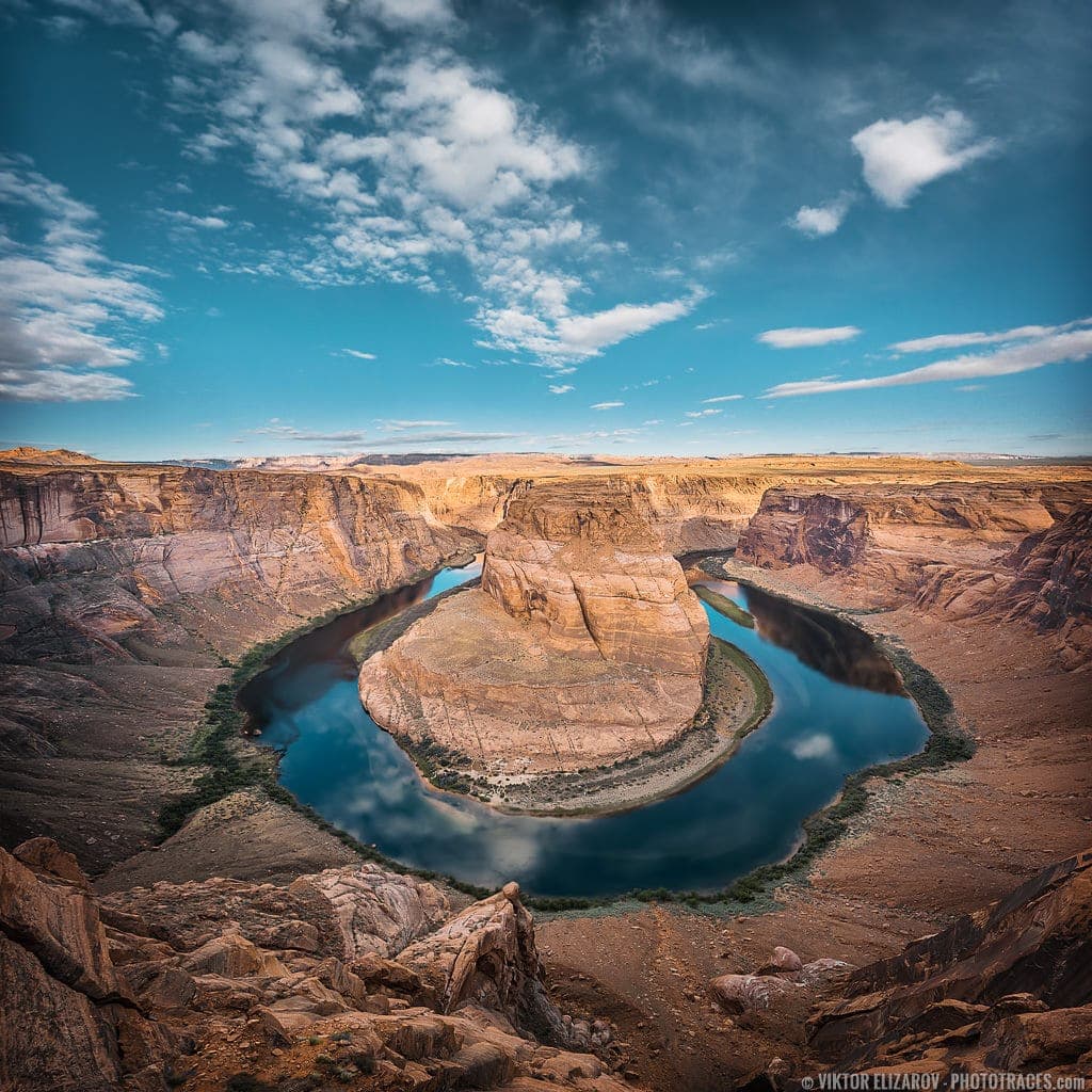
If you stay on Route 89, you have the opportunity to visit Horseshoe Bend, Glen Canyon Dam, and Lake Powell. It is absolutely worth visiting these places, but you have to be ready to face crowds of tourists everywhere.

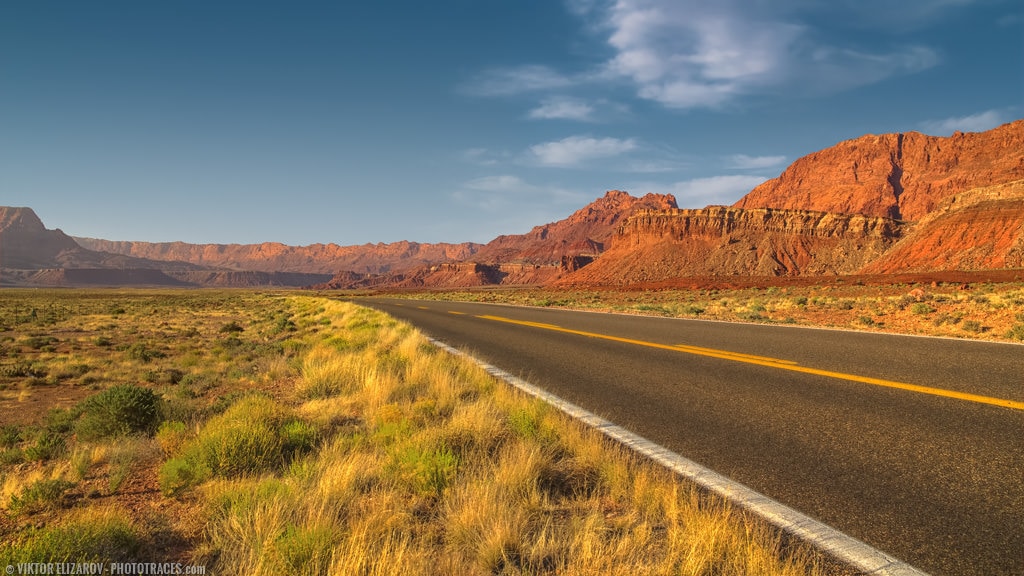
If you take Route 89A, you will experience one of the most beautiful drives along the Vermillion Cliffs and cross the Navajo Bridge with the Colorado River below. And, you won’t see many people around.
When I have a choice, I always pick Route 89A.
It was late morning when we turned on Route 89A. We had enough time to hit all our favorite spots along the way.
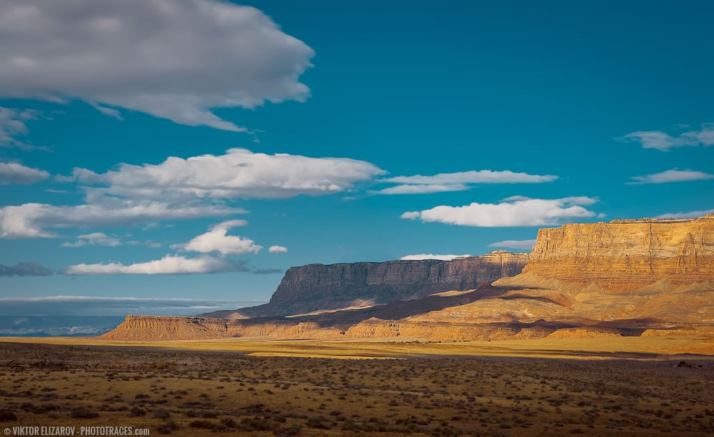
Echo Cliffs
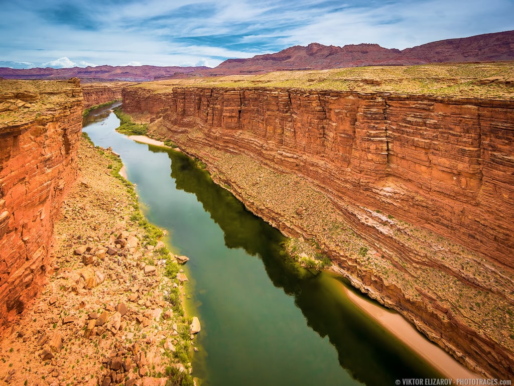
For the first 20km or so, you drive in the valley with the Echo Cliffs along the right with the Vermillion Cliffs in the distance. In the middle, the Colorado River runs deep through the Marble Canyon.
Navajo Bridge
The next stop is the Navajo Bridge. The original bridge was built at the beginning of the 20th century as a one-lane bridge. When the new, modern bridge was constructed in 1980, the original bridge was preserved as a pedestrian crossing bridge.
Related: Monument Valley (opens in a new tab)” href=”https://www.phototraces.com/b/valley-of-the-gods-utah/” target=”_blank”>Velly of the Gods – Poot Man Monument Valley
Walking across the bridge provides us with the opportunity to take photos from unusual and unique vantage points. You can even set up a tripod.
I never miss an opportunity to walk across the bridge and enjoy the view even when the weather is not ideal for photography.
Glen Canyon
Glen Canyon is the recreation area run by National Park Services, which means we had a chance to use our new Annual Pass for the first time. It is a short drive through a deserted area with dramatic rock formations and almost no vegetation.
Lees Ferry
Lees Ferry is the only place in over 1000km where you can access the Colorado River by car. Before the Navajo Bridge, Lees Ferry was the only spot where travelers could cross the river between Arizona and Utah.
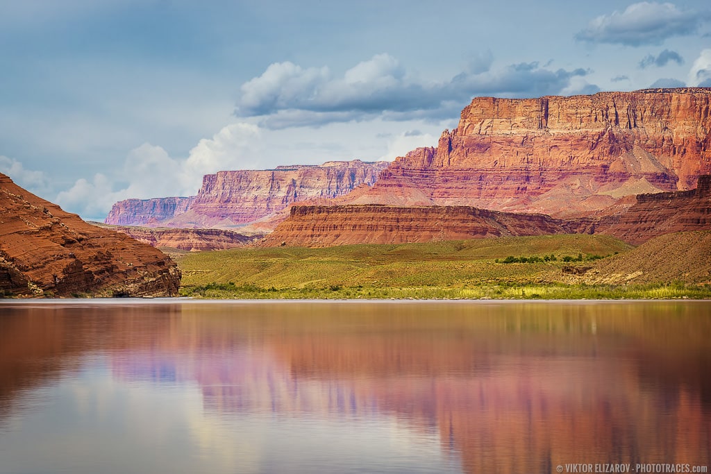

These days, it is the most popular spot for the departure of Colorado River and Grand Canyon multi-day rafting tours. The longest tour lasts almost two weeks!
Vermilion Cliffs Valley
The final stretch of the Route 89A drive runs through a beautiful valley along the Vermilion Cliffs. It is a 45km drive with an empty road ahead, endless plains on the left, and the Vermilion Cliffs so close on the right that it feels like you can reach out and touch them.


House Rock Road
Just before you reach the end of the valley and the beginning of the mountainous road toward the Grand Canyon’s North Rim, we turn right and head to House Rock Road.
The Vermillion Cliffs is a vast, mountainous area with Route 89 running along the northern border of the national monument, Route 89A running along the southern border, and House Rock Road running through the mountains.
Related: Exploring Utah’s Backcountry – Cottonwood Road
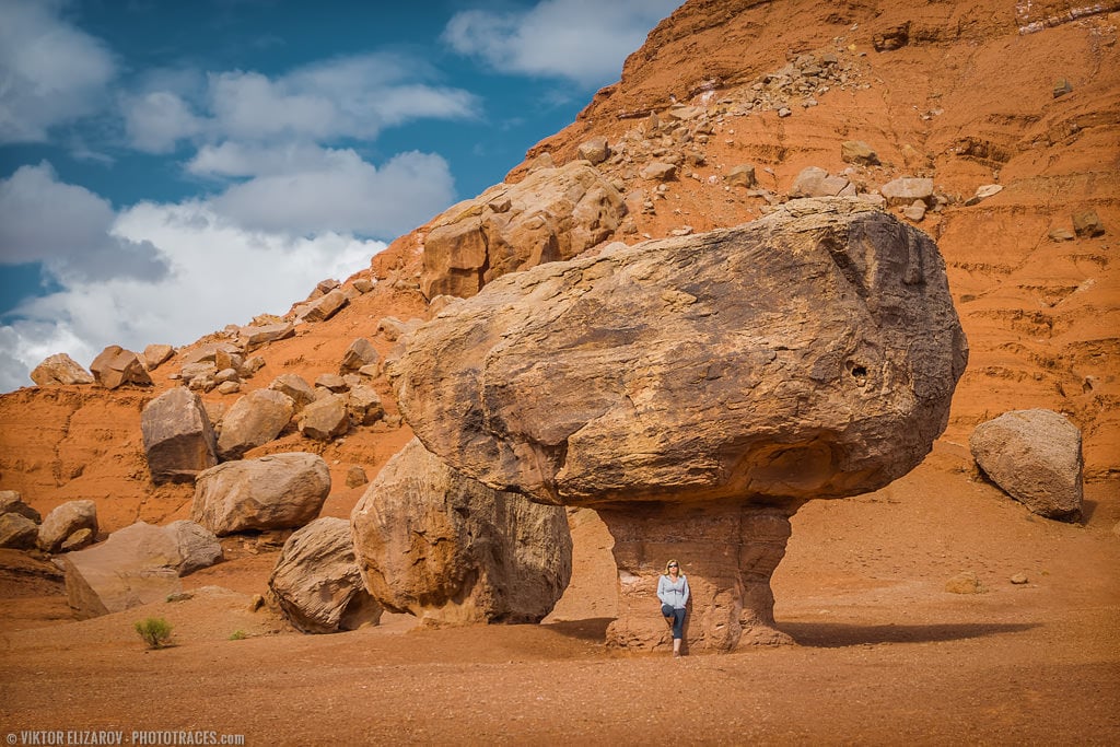
House Rock Road is a dirt road and, in some places, is fairly rough but it provides access to some of the most spectacular locations in Northern Arizona and Southern Utah. The road is extremely popular among hikers and photographers.


Stateline Campground
We arrived at Stateline Campground early in the afternoon and found that eight of the nine campsites were empty. We picked the best spot, had a quick lunch, and drove north on House Rock Road.


Buckskin Gulch
Last year, the highlight of our trip was our visit to Wire Pass Slot Canyon in the same area of the Vermilion Cliffs.
This year we decided to explore the Buckskin Gulch trail.

Of course, our first choice was to visit the elusive the Wave Canyon, but since it has become such a popular spot among photographers, the Utah Bureau of Land Management has limited the number of visitors to 24 per day. You have to go through a lottery process to obtain a pass, which means Wave Canyon was out of reach for us.
Maybe next time.
We spent the second part of the day hiking along Buckskin Gulch trail, which is a long, flat hike that is not very demanding.


We walked through a series of small valleys accessing each of them through narrow passes between the cliffs. Each valley had a distinctive look with different rock formations and vegetation. Everywhere we turned, we were accompanied by wild rabbits.
Related: Exploring Arizona Landscapes
Over a four-hour hike, we met only one other hiker—a German man who regularly visits Utah and Arizona. This made our complaints pointless that Eastern Canada is too far from the Southwest.


It was a very hot day with temperatures approaching 30C, but as soon as the sun disappeared behind the mountains, the temperature dropped immediately. We had to dig out warm clothes to enjoy our soviet style beef dinner by the fire.
By sunset, the campground was full with some hikers forced to sleep along the side of the road.
At night, temperatures were close to freezing but we did not feel it. We were exhausted and slept like babies.