


The full article was first published in Travel Awaits on June 16, 2021
My husband
and I have been traveling for 14 years since the time we met and married. And
whenever we are asked the question “What is the most memorable trip you have
ever taken?” our answer is still, after all these years, the same. It happened
because we wanted to go back from Fairbanks, Alaska to Seattle, Washington on a
different route from the way we came up from Calgary, Alberta. That was a consequential
decision because it led to our epic Yukon Arctic Road Trip. That it was almost fall
added to the color and the spectacle. Let me tell you this once-in-a-lifetime story.
Chicken, Alaska

After a
short visit to experience Christmas in September in North
Pole, Alaska, we were ready to go back to mainland USA. But we thought of
not going back not on the same Alaska Highway. Instead, we found an interesting diversion:
east to Chicken, Alaska, and the Top of the World Highway to the historic City of Dawson
Yukon before going south on Klondike Highway that drops down to Cassiar Highway
in British Columbia.
The road to Chicken, Alaska was all
gravel, a prelude to our next several days of travel. The town’s summertime population was 32 at
the time (wintertime, seven). It got its name because the residents could not
spell the word “ptarmigan,” the actual inhabitant. This was the most rustic camping we had to
date. There were two campgrounds, one with gold-panning activities up the hill
and the other with the country store down below. We chose the former and were rewarded with a
spectacular sunset.
Top of the World Highway

This 79-mile-long highway begins at a junction with the Taylor Highway and travels east to
Dawson on the western banks of the Yukon River in the City of Dawson. It has been
in existence since 1955 and is only open from mid-May to mid-October, sometimes not
even. It is one of the most northerly highways in the world. Two farther north,
the Dempster Highway and the Dalton Highway, both lead to the Arctic Circle.
The Top of the World
Highway deserves its name because it skirts the crests of endless mountains, giving only random peeks
of the valleys below. Since the highway is above the tree line, the whole route
was devoid of trees. We got a preview of this kind of alpine tundra in Denali
National Park. But, here it was in great splendor, resembling an expansive carpet
of red, orange, gold, and yellow that covered the undulating mountain tops, setting
it apart from the great big, blue sky.
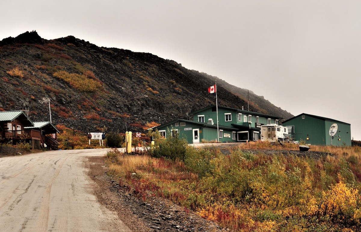
The Poker Creek –
Little Gold Creek Border Crossing was open (pre-Covid) during the summer months
from 8 am to 8 pm (Alaska time). It was unlike any other border I have seen.
There was nary a soul, just my husband, the immigration officer, and me. And
soon after, we reached the highway terminus where a ferry connects West Dawson
to Dawson in summer (the residents use an ice bridge in winter). My husband and
I, Star (our RV) and Vino (our scooter), rode the small ferry. Such exciting
times!
Downtown Dawson
The City of Dawson is inextricably linked to the
Klondike Gold Rush (1896–99). It served as Yukon’s capital from the territory’s
founding in 1898 until 1952, when it was moved to Whitehorse. During its
heyday, there were about 40,000 living in the city but now the population stands
at only 1,375. Even then, it is the second-largest town in the Yukon, that part of Canada that is
remote, pristine, and sparsely populated, just like the two other Canadian Territories,
Nunavut and Northwest.

But its “golden”
past is kept alive by colorful saloons, thriving general stores, and old
theaters in the architecture of its historic past. All new construction must
comply with standards to ensure this appearance. This historic core of the town
is a National Historic Site of Canada. Every February, Dawson acts as the
halfway mark for the Yukon Quest
International Sled Dog Race when mushers do a mandatory 36-hour layover to prepare
for the second half of the world’s toughest sled dog race.
The town is
so interesting that the area around it is also featured prominently in the
novels and short stories of American author Jack
London, including his classic, The
Call of the Wild. The famous writer lived in a rustic Dawson cabin up the
hill from 1897 to 1898. Surprisingly, it was side-by-side with another cabin,
the one owned by the Canadian poet Robert Service. A great find for us.

Sites of the Klondike Gold Rush
It is also
in the area when, in the spring of 1898, gold was discovered in nearby creeks. Thousands
arrived and the famous Klondike Gold Rush began. Later, large gold dredges started
an industrial mining operation, unearthing large amounts of gold out of the
creek s. The landscape changed, the creeks shifted, and a network of canals and
dams were built to produce hydroelectric power. The dredges shut down for
winter, except for Dredge No. 4 which is now the Klondike
National Historic Site of Canada. That’s where we saw what they claimed to
be the largest gold steam shovel in the world.
Dawson was definitely worth the diversion.

Dempster Highway
Except for
the fact that I was so disappointed I did not get to witness the Aurora
Borealis there. So the day we were to leave for Whitehorse to resume our trip
back to the lower 48, I pleaded with my husband to go north instead, up the Dempster Highway to the Arctic
Circle. We passed up the opportunity in Fairbanks, Alaska, even though Dalton
Highway is shorter and better. I told him we will probably regret it if we did
not do it; only about 3 days and 2 nights separated us from the bragging
rights.
Luckily, he
agreed even if he knew it would be a rough journey, especially since we had an
old second-hand 24-foot RV. The Dempster Highway is a 457-mile road that
connects the Klondike Highway in the Yukon to Inuvik, Northwest Territories
(now there is even a new highway that extends to the Arctic Ocean). It was a
dirt-gravel road; rocks were put together and sealed/packed by mud. My husband
said that if it looked like Star would not be able to handle it, then we
would just go back. But we didn’t. Many times we had to slow down to 5 mph, averaging
about 25. At the end of the trip, Star had to have all her shocks replaced. But
it was all well worth it.

Tombstone Territorial Park
Crossing the
Ogilvie and Richardson mountain ranges had been a succession of one beautiful
scene after another, as the trees of the valley changed into shrubs of the
subalpine hills and into the moss, lichens, and fungi of the alpine tundra, all
in blazing fall colors. Every fifteen minutes, I would ask my husband to stop
for yet another spectacular view. The day after, going down from the Circle,
the colors seemed even more vibrant, more of everything had simply turned
brighter yellow.

\
Everything
seemed to gather, collect, and distill at the Tombstone
Territorial Park. It stands near the southern end of the Dempster Highway,
protecting over 2100 square km of rugged peaks, permafrost landforms, diverse
flora, and fauna, including Dall’s sheep, caribou, moose, and black and grizzly
bears. The Park is also a birders’ delight, with about 150 bird species
identified. A notable feature is Tombstone Mountain which resembles a grave
marker, that’s why the name. Tourism operators offer excursions into the Park during the summer
months. There is an interpretive center as well as several camping sites. But
we were simply content with looking at the spectacular scenery.
Eagle’s Plains Hotel and Service Station

And there is
even a place where you can rest, on the way up or the way down, halfway between
Dawson and Inuvik. Eagle’s Plains
has a hotel with basic rooms, a cafeteria, a gas station, and several RV spaces.
A storm had developed, the winds were
strong, and the cold was biting. But we survived the night in Star because we
kept each other warm. In the morning, the sun was shining again.

On the way down we chose to boondock at a spot
we found near where I saw a Dall sheep grazing at the river bank the day
before (headline photo). On the other side of the road was a hill ablaze with red, yellow,
orange, and gold. Before nightfall we spent the time looking at the different
plants up close, to discover how such a magnificent tapestry was woven. And we
were happily surprised to meet a European couple who had also camped the night
but farther from the river.
Arctic Circle

We saw an
elephant rock atop a hill, fluted whitish mountains, little lakes, colorful
carpeted fields, rushing rivers, and all things beautiful. Imagine that this is
the land first seen by those who migrated from Asia to North America. It is a beautiful, untouched wilderness, vast and still. When we reached the Arctic Circle-Yukon
at latitude 66 degrees 33 north, we were alone at the arch proclaiming that one-of-a-kind
spot on earth. It was cold. The winds were biting. We could not stay long. Shivering,
we hurriedly put our camera on its timer, placed it on the lone picnic table,
and took our once-in-a-lifetime shot.